 Summary
 Summary
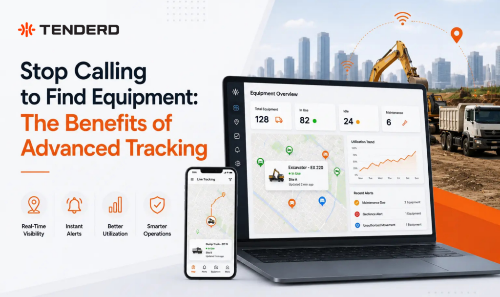
Advanced tracking replaces the daily phone-around with a live, color-coded map showing exactly where every machine is and what it’s doing, whether it’s working, idle, switched off, or offline. Fleet and site managers get status at a glance instead of chasing down subcontractors and site supervisors for an update, and can replay any day’s movement to confirm where a machine actually was. On multi-contractor sites, this single view is what turns fragmented equipment usage into coordinated allocation.
Key Takeaways
- A color-coded live map (green, yellow, red, grey) shows whether a machine is working, idle, off, or offline without opening a single record, ending the need to call a supervisor for a status update.
- On ALEC’s Abu Dhabi SeaWorld project, centralizing equipment visibility across 130 monitored assets and 17 subcontractors produced a 25% improvement in equipment utilization and a 34% reduction in downtime.
- Day-by-day location history lets a manager replay a machine’s route, ignition time, speed, and distance covered for any past date, settling disputes about hours, delays, or unauthorized use with actual data instead of memory.
- Location alone doesn’t stop the calling. A full per-machine record, tying GPS position to documents, the assigned operator, and violation history, is what lets one person answer a question that used to take three phone calls.
Why the Phone Call Still Happens on Multi-Contractor Sites
The phone-based habit persists because equipment usage on a large project is fragmented by default. Each subcontractor typically manages and tracks its own machines separately, if it tracks them at all. The general contractor coordinating the overall project has no single view across all of it, which creates a predictable set of problems: requests for additional machines that aren’t backed by any usage data, equipment sitting idle in one zone while another zone assumes none is available, and delays tied to uncertainty about which subcontractor’s equipment is actually accessible and where.
None of this is a communication failure so much as a visibility gap. Supervisors and subcontractors are answering honestly when they say they aren’t sure. The information genuinely doesn’t exist anywhere central until someone tracks it down.
What Changes When Equipment Is Actually Trackable
- Status at a glance: a color-coded map answers “is it working, idle, or off” without a call or a report request.
- Replay any day: settle disputes over hours, location, or delays with an actual route and timeline instead of someone’s recollection.
- Idle patterns made visible: heatmaps surface where machines sit running but producing nothing, so idle time becomes something to act on rather than something discovered after a rental is already booked.
- One record per asset: location, engine hours, documents, the assigned operator, and violation history live in the same profile, so answering a question about a machine doesn’t require checking three separate places.
- Geofence awareness: automatic entered/exited logs against every project site, camp, or restricted zone remove the need to manually confirm whether equipment reached or left a location.
Multi-Contractor Visibility in Practice: The ALEC Case Study
ALEC Engineering was the main contractor on the Abu Dhabi SeaWorld project, responsible for coordinating the work of 17 subcontractors across a large, complex site. Fragmented equipment usage created inefficiencies and safety risks: no centralized view of equipment allocation, frequent requests for additional machines without supporting usage data, redundant or idle equipment across different zones, and subcontractor concerns about delays tied to limited access to information.
To prevent delays and reduce these risks, ALEC made the strategic decision to centralize and directly manage all equipment supply. TENDERD installed sensors across the fleet to capture real-time engine hours and utilization data, giving ALEC a centralized dashboard to monitor performance, identify underused assets, and optimize daily equipment allocation across all 130 monitored assets.
The results: a 25% improvement in equipment utilization and a 34% reduction in equipment downtime. Better visibility and proactive equipment management also led to fewer idle hours and improved availability, and clearer shared data streamlined coordination and communication with subcontractors, helping keep the project on schedule without requiring extra equipment.
Where Tracking Has Limits
Tracking data is only as useful as the geofences and thresholds behind it. A project site that hasn’t been mapped as a geofence won’t generate entry or exit alerts for it, and violation thresholds left at generic defaults may not reflect how a specific operation actually runs. Tracking also depends on device connectivity, so remote or low-signal areas can affect how current the data is.
It’s also worth being direct about what tracking doesn’t do: it reduces how often teams need to call around to locate equipment or confirm status, but it works alongside good site communication and coordination practices rather than replacing them outright. And the multi-contractor benefit specifically depends on subcontractor-supplied equipment being enrolled on the same platform. Coverage that stops at the general contractor’s own fleet only closes part of the visibility gap.
Getting the Most from Advanced Tracking
- Map every active project boundary, camp, and restricted zone as a geofence before rollout, not reactively after a gap is noticed.
- Enroll subcontractor-supplied equipment on the same platform wherever possible, so it appears in the same view instead of being tracked separately or not at all.
- Set violation and idle thresholds to match how the operation actually runs, rather than leaving generic defaults in place.
- Build a routine of reviewing History replay for high-value or frequently disputed assets, rather than only pulling it up after a disagreement.
- Keep the Documents and Specifications tabs current for each machine, so the asset record stays useful for maintenance and compliance, not only for location.
Manual Location Tracking vs. Real-Time Advanced Tracking
| Manual (Phone-Based) Tracking | Advanced Tracking | |
| How you find equipment | Phone calls to site supervisors and subcontractors | Live, color-coded map updated continuously |
| Confirming machine status | Guesswork based on the last report someone remembers | Working, idle, off, or offline shown instantly |
| Settling a dispute over hours or delays | Relies on memory, paper logs, or nobody’s sure | Actual route, ignition time, speed, and distance replayed for any past date |
| Visibility across subcontractors | Each subcontractor manages its own equipment separately | Owned and subcontractor equipment visible on one dashboard |
| Idle equipment | Often discovered only after a rental request is questioned | Idle patterns visible directly, including heatmaps of where machines sit running unused |
| Asset record | Scattered across spreadsheets, folders, and paper documents | One profile per machine holding location, documents, specifications, operator, and violation history |
The Bottom Line
The phone call to locate equipment isn’t a communication problem. It’s what happens when the information a manager needs doesn’t exist anywhere central. Advanced tracking closes that gap: a live status view that ends the guessing, a history that replays instead of relying on memory, and one record per machine that ties location to everything else worth knowing about it. On sites with a single fleet, that’s a convenience. On multi-contractor sites like ALEC’s Abu Dhabi SeaWorld project, where 130 assets moved across 17 subcontractors, it was the difference between fragmented usage and a 25% gain in utilization.
See where every machine on your site stands right now, whether it’s your equipment or a subcontractor’s. Book a demo to see the live map and asset record in action.
Frequently Asked Questions
What is equipment tracking in fleet management?
Equipment tracking is the part of a fleet management platform that shows where each machine is located, what it is currently doing (working, idle, off, or offline), and where it has been over time. In TENDERD's Track module, it also functions as a master record for each machine, combining location with documents, specifications, and violation history.
How is advanced tracking different from basic GPS tracking?
Basic GPS tracking typically shows a location pin. Advanced tracking adds operational context: a color-coded status per machine, day-by-day route and usage replay, geofence entry and exit logs, and a full per-machine record linking location to documents, the assigned operator, and violation history.
Can advanced tracking work across multiple subcontractors on the same site?
Yes, when subcontractor-supplied equipment is enrolled on the same platform. On ALEC's Abu Dhabi SeaWorld project, centralizing visibility across 130 assets and 17 subcontractors on one dashboard led to a 25% improvement in equipment utilization and a 34% reduction in downtime.
Does advanced tracking replace the need for good site communication?
No. Tracking reduces how often teams need to call around to locate equipment or confirm status, but it works alongside site communication and coordination practices rather than replacing them entirely.
How does tracking help resolve disputes about equipment hours or delays?
A history feature lets managers select a past date and replay the machine's actual route along with ignition time, speed, and distance covered, giving an evidence-based answer instead of relying on memory or paper logs.
What data does advanced tracking capture beyond location?
Beyond GPS position, a per-machine record can include engine hours, odometer readings, fuel level, assigned operator, uploaded documents, custom specifications, and a violation history such as overspeeding, harsh braking, or geofence breaches.